The intersection of Yonge Street and Langstaff Road (Hwy. 7) has changed so much, the roads no longer intersect, writes Andrea Kulesh
Published online by the Richmond Hill Liberal on June 23, 2022
In the late 1700s, European settlement began in the area where these two roads would be built. The land on the northwest corner, Lot No. 35, was purchased by the Abner Miles family, some of the earliest arrivals. John Langstaff arrived from New Jersey a few years later and soon met and married Lucy Miles. Upon her father’s death, around 1808, they took ownership of the property. John was a very industrious person. He began as a teacher in the Thornhill area, joined the York militia to fight in the War of 1812 and, upon returning, supplemented farming with multiple businesses including a store, a smithy and factories for the manufacture of pails, shingles and eaves troughs. The area soon came to be known locally as Langstaff Corners.
We have all noticed that Richmond Hill’s Yonge Street corridor is rapidly changing. Future plans for major intersection highrise “hubs” are underway and many well-known “local” corners will alter so much that they will become unrecognizable. One such “corner” that has already changed multiple times is Yonge Street and Langstaff Road (Hwy. 7). Now-a-days, Hwy. 7 doesn’t even intersect — it is a raised roadway with ramps for access to Yonge Street.
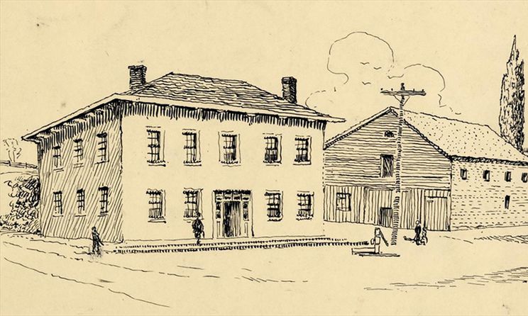
Yonge quickly became the major link north from York. Businesses were taking root to serve local farms and to facilitate travel more easily on Yonge. By the 1830s, the Upper Canada Legislature had authorized tolls to be collected to fund road improvements, and Toll Gate No. 3 was erected at the intersection. By mid-century, Langstaff Corners had become a major stopping place for travellers on the road from Toronto to Richmond Hill and north. The toll house stood on the southwest corner and alongside it, Langstaff’s first post office opened in 1870. On that same corner, for some years, the Langstaff family enjoyed riding around an oval half-mile racetrack. The Yorkshire House, a hotel under the management of William and Jane Cook occupied the northwest corner. The Munshaw family farmed the southwest corner throughout much of the 19th century.
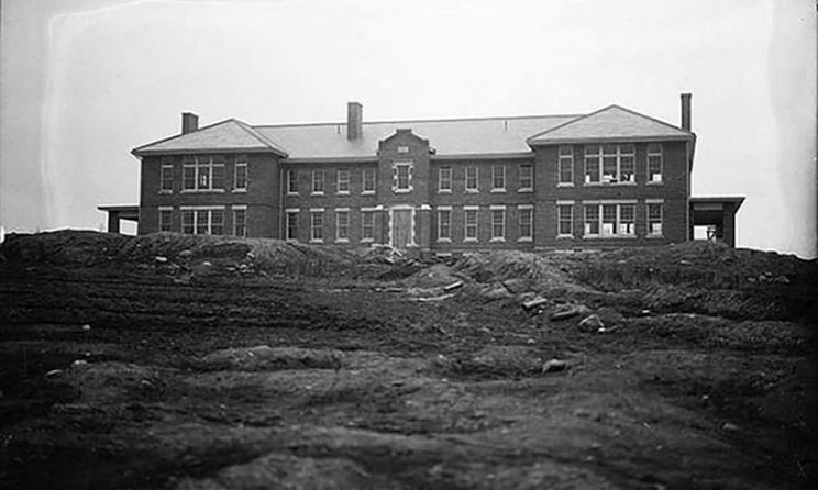
The original Langstaff farm stayed in the family until 1893 when the Boyle family purchased the property. The City of Toronto subsequently bought the land in 1911, just prior to the First World War, when it became part of the city’s Industrial Farm and came to be known as the Langstaff Jail Farm or the “Jail Farm.” This institution was active until the late 1950s when the operation was finally closed. The land stood unused for years with many of the buildings standing empty.
In 1978, the Langstaff GO Station was opened along the Richmond Hill Railway Line, replaced by a new, larger and more modern one in 2005. Also, in 1978, proposals for a planned hydro corridor were tabled resulting in a large swath of the Miles/Munshaw/Langstaff farmland being utilized for this purpose, paralleling Hwy. 7 on the north side by 1985.
By 1982, Toronto council began selling the Langstaff Jail Farm property, (it encompassed a desirable block of real estate bounded by Yonge, Bayview Avenue, Hwy. 7 and 16th Sideroad). Developers quickly purchased this very large acreage and an incredible amount of development began quickly including housing, stores, schools, parks and roads. The new High Tech Road became the east-west gateway from Yonge to Bayview with multiple big box stores lining the south side. “Old” Langstaff Road remained, but the access was moved south of Hwy. 7 off Yonge Street.
The ever changing Langstaff Corners continues to have huge pressure on it. The Ontario government has announced its intention to increase population density through its proposed “transit oriented community” (TOC) — planned developments in the areas located on both sides of Hwy. 407 at Yonge Street — a new skyline will appear. In the Toronto Star on April 16, 2022, Ontario Infrastructure Minister Kinga Surma was quoted as saying “a TOC is a place where people will wake up in the morning, take an elevator down, perhaps drop off their child at daycare, access a (transit) station, go to work, come back home on transit and pick up something for dinner at a local grocery store.” Langstaff Corners will be developed for this new purpose.
Such is the future of the corner where Toll Gate No. 3 stood for the purpose of collecting tolls to improve a very early Yonge Street — the gateway to the north. It will take years for this plan to come to fruition, but the ongoing history of “Langstaff Corners” continues …
-Andrea Kulesh is the vice-president with the Richmond Hill Historical Society
